Monsoon Mayhem: How a Massive Landslide Choked NH‑2
Summary
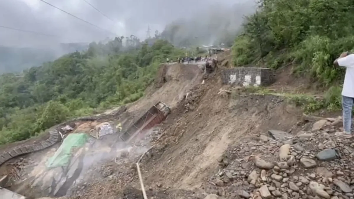
A powerful landslide triggered by heavy, unrelenting rain has severely disrupted traffic on NH‑2, the critical road linking Manipur and Nagaland. Occurring near Kisama/Phesama on the outskirts of Kohima, the disaster caused a 25‑meter section of the highway to sink, leaving multiple trucks stranded and halting interstate movement . Authorities have issued travel advisories, diverted heavy vehicles to Khuzama and Sechü‑Subza, and rerouted light vehicles via Demori Cove–Phesama and BSF Camp–Mao Gate until road clearance occurs .
Introduction: A Vital Highway on the Brink
Picture NH‑2 as the lifeline of Northeast India—a narrow artery pulsing through lush hills, bridging Nagaland and Manipur. Now imagine that lifeline suddenly severed. That’s exactly what happened when heavy rains unleashed a massive landslide near Kisama/Phesama, collapsing a vital stretch and disrupting trade, transport, and daily life . Let’s open the lid on this chaos: what triggered it, what it means, and how the region can recover and build resilience.
1. Rain, Slopes, and Soil: Nature’s Perfect Storm
a) How Rain Weakens Mountains
Monsoons bring beauty and bane. Water saturates steep hill slopes, loosens soil cohesion, and amplifies gravity’s pull—a lethal mix of mud, rock, and uprooted vegetation. Official reports confirm heavy rain in the days leading up to the incident, saturating fragile terrain already prone to slipping
b) Trouble Spot: Phesama/Kisama
This stretch, near landmark heritage sites, had already experienced subsidence before; officials described it as a “sinking zone.” Such weak geological zones, exacerbated by deforestation and slope-cutting, were inevitable waiting for the next heavy monsoon to collapse .
2. The Scene That Metromorphosed Overnight
a) Collapse Scale and Immediate Impact
A 25-meter chunk of NH‑2 literally sank; not just cracks, but wholesale asphalt loss. Trucks carrying essentials were caught off-guard: one truck was even swept off. With no alternate routes nearby, dense queueing and halted commerce instantly followed.
b) Emergency Response Unfolds
Nagaland’s DC quickly issued travel advisories, outlining precise stoppages for heavy vehicles at Khuzama and Sechü‑Subza. Alternative one-way routes were opened for lighter vehicles—Demori Cove to Phesama toward Kohima and BSF Camp–Mao Gate toward Manipur . Safety efforts kickstarted, especially regarding exposed electric wires and unstable poles.
3. Ripple Effects: Beyond Disrupted Commutes
a) Trade and Supply Chain Jitters
NH‑2 isn’t only for personal travel—it’s for essentials. The highway fuels trade in goods moving from Nagaland into Manipur and beyond. With truckloads stranded, supply chains backlogged and prices jittery, panic set in.
b) Social and Civic Fallout
People depending on cross-border travel—students, laborers, medical patients—were stranded. Anxiety about longer detours, impromptu expenses, and missed opportunities quickly spread across communities.
c) Eco & Geotech Alarms
Landslides erode river banks, pollute water systems, and rip vegetation. And with one collapse already, everyone’s asking: when will the next one happen?
Conclusion: From Disaster to Durable Design
The landslide on NH‑2 is more than a traffic nightmare; it’s a lesson etched in mud. Swift response is crucial, but true resilience stems from mindful planning, environmental respect, and community vigilance. If Manipur and Nagaland invest in prevention today, tomorrow’s rains won’t drown their lifeline. Let this be a turning point—a shift from reactive to rock-solid infrastructure thinking.
FAQs
1. How long will NH‑2 remain closed?
It depends on the weather and slope reinforcement. Expert estimates suggest 2–6 weeks, pending safe completion of debris clearance and rebuild.
2. Are alternate routes safe?
Yes, but they’re single-lane and hilly. Proceed with caution—expect slow traffic, no shoulder paths, and minimal roadside support.
3. Could this cause more landslides nearby?
Absolutely. Disturbed hillsides increase vulnerability. Ongoing monitoring is critical to prevent secondary slides.
4. Who’s responsible for reconstruction?
The National Highways Infrastructure Development Corporation Ltd. (NHIDCL), state PWD, district administrations, and central highway authorities will coordinate repairs.
5. What should locals do?
Stay updated through official channels, avoid NH‑2 until safe, use alternate routes, report hazards, and join community initiatives for slope greening.